
This field work was performed during May and June 2015 in collaboration with hydro-engineer Josif Miti, who prior to the survey, prepared a desk-based research about the natural hydro network and traditional irrigation systems of the study area.
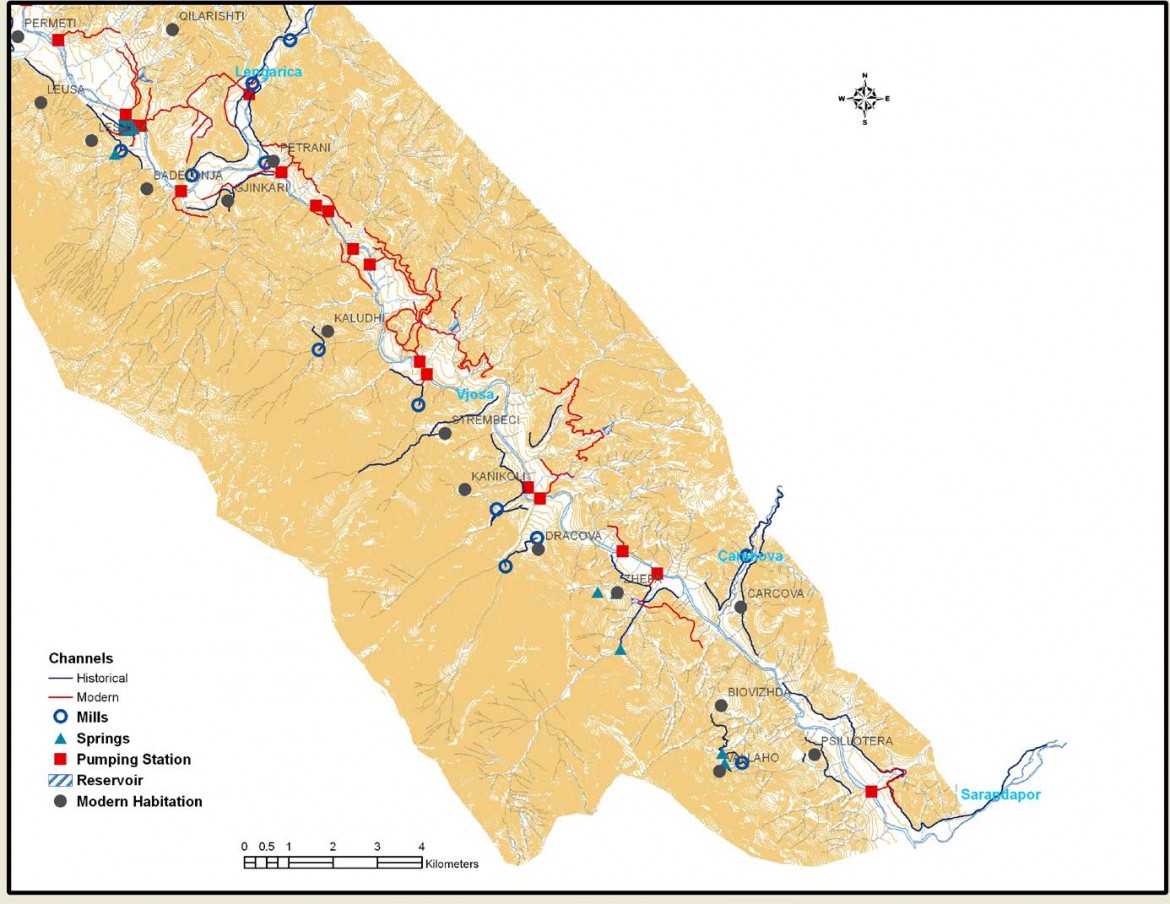
The survey, which focused on the southern part of the study area, brought considerable information, useful in producing a first complete map of the hydraulic networks and the related structures, including a first chronological classification of their construction and typology. Two building phases are clearly noted: a) historic channels built at least since the Medieval Period; b) and a powerful irrigation network, established during the communist period (years 1945- 1990).
To the Medieval Period are related a number of irrigation channels, of a considerable length, varying from 1.2 to 9.8 km, which run on both sides of River Vjosa bed. They are mainly fed by other affluent of Vjosa River, such as the rivers of Sarandapor, Çarshovë, Lengaricë, etc., and a number of seasonal and perennial springs and streams as in the case of Vllaho Psilloterë, Draçovë, and Kanikol. Their primary function was to irrigate agriculture lands located on the lower river terraces, however, a number of gristmills, some of which used also for distillation purposes, appear to have been built along their flow. Functioning at the same time as drainage systems for collecting winter and spring flows, the historical channels may have had an important role in protecting agricultural lands from erosion processes.
The study suggests that irrigation channels and the related water-powered mills were likely to have had three types of administrations: property of religious institutions, which also owned considerable agricultural lands; landlord’s ownership; and a small number were joint property of local villages.
Additionally, a number of cisterns (locally known as topila), which were used to irrigate the small gardens, were recorded in the historical villages of the valley.
The identification of these irrigation channels enabled us to obtain a preliminary delineation of the historical agriculture parcels, supporting also the assumption which suggests the long-term utilization of lower river terraces as agriculture lands.
In the communist era, an intensive agriculture program was applied in the country, consisting on the opening of new agriculture lands and introduction of new plants, which of course required the construction of a more complex and powerful hydraulic infrastructure. Part of this system, such as irrigation and drainage channels, reservoirs, pumping stations, and etc., were identified and recorded during the survey. It seems that a major part of the traditional channels were reused in the communist era, though with large modifications in order to adapt to the new and complex irrigation network. Also, the drastic changes of this period caused the loss of many of the traditional ways of management and ownership of the irrigation systems.
Today, little is utilized from all this complex system (of both medieval and communist periods), and this is mainly due to the abandonment of agriculture, migration processes, and malfunction of governmental and local policies in the management of hydro-systems. All this has consequently increased significantly erosion processes, causing, in certain area the landscape deterioration.
However, this later years, it is noted a tendency for the recovery of many of these past irrigation systems. In this frame work, during 2016, CeRPHAAL and the University of Granada, in collaboration with the municipality of Përmet and the local community, intend to recover the historic medieval irrigation channel at Vllaho-Psilloterë.